 The fortunes of cities rise and fall with their connections to the rest of the world: seaways, airways, roadways, a principle so fundamental that the word “arterial” is defined not only as relating to our blood circulation but as a major road, period.
For Flagstaff, I suppose the economically most important are the run-of-the-mill interstates that link us to bigger populations elsewhere, built to resemble any other interstate anywhere. Sure, there may be mountain and desert vistas in the distance, but the experience of driving those arterials isn’t that different from driving in any other state.
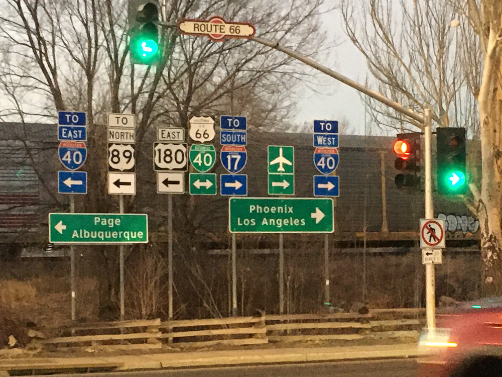
I’ve always had a preference for what the author William Least Heat-Moon famously called “blue highways,” the smaller, windier roads that guide travelers to places that are, if not off the map, at least farther afield from the main patterns of circulation. So it is perhaps no surprise that to me Flagstaff is defined less by the major roads than by the blue highways that crisscross here. Even their numerical designations are more interesting than those of the interstates, like that of the famously alliterative and tuneful Route 66. But for me the road that most defines the place is one that is, if not blue, at least purple—pretty much literally so in the case of its passage through the Painted Desert—namely Highway 89.
Say the number slowly, drawing out the final syllable into a glide that practically demands inclusion in a song, an imperative that I sadly find beyond my capabilities. Graphically, too, 89 speaks volumes. The first digit infinity tilted on its side as if in ironic commentary on the endlessness of vast Painted Desert vistas, the second with its tail sliding back around as if to reflect the local Navajo cosmology that sees the core of the world as bound up among the region’s encircling mountain peaks.
For me, Highway 89 is the road that most defines our place, the long ribbon of asphalt linking us to places that although distant are simply ingrained into the city’s soul: the sun-glittering Navajo highway towns, the piney ramparts of Grand Canyon, the canyon intimacies surrounding Lee’s Ferry and Page.
For me, 30 years of experiencing Arizona are inextricable from both the drive north and the drive south, from the weary excitement of being done with the packing at last and getting on the road, from the mingled relief and sadness that always comes at the gritty end of a trip, the looking forward to a shower and a soft bed inextricable from the knowledge that coming home means transitioning from the extraordinary to regular day-to-day life. If a city’s economic vitality is inextricable from the health of other places strung out along those arterials, its aesthetic and maybe even spiritual health depends on what its people can do “out there” to sustain mind and heart and body.
My Highway 89, is different from yours, from everyone else’s, because no one else has experienced the road in quite the same way. No one else has had exactly the same experience of breaking down five miles north of The Gap, more than 20 years ago now, and hiking fast up a limestone hill to try to see if it was possible to corral a cell phone signal (no, it was not), but fortunately being offered a ride by a party of Mormons going the other way. They offered to drive us to the gas station in that most aptly named town that sits below the only substantial break in the long face of the Echo Cliffs. No one else experienced coming back south from the Arizona Strip with a trailer hauling two ATVs in the fierce spring winds and watching the fuel gauge inclining left so fast that we had to stop to refill our tank from the gas cans in front of the Sacred Mountain Trading Post, or of crossing the highway in the wake of a Navajo man who announced he was going to run to Window Rock to protest the proposed Escalade project at the Little Colorado confluence.
But perhaps my most vivid memory of Highway 89 is more recent, from a summer trip in which I’d driven to western Colorado to interview a long-retired uranium geologist. On the way home, late in the day, I picked up a hitchhiker in southeast Utah. Jeremy was a young man with a reddish beard, a small backpack, a vest and no shirt, and like no doubt many before him he had with him a cardboard sign that read “West/California.” I looked him over and thought, why not. And so for the next couple hours, I heard his story, how he had traveled from Michigan with a young woman but somewhere in Colorado she took the car and went off without him, leaving him to hitchhike by himself.
He was coming west, it turned out, to see a couple of siblings or half-siblings whom he’d never met before; he was born from a surrogate womb, and had only recently learned from a social media contact that there was a family from his biological mother that he’d never met or heard of before. So here he was, hitching through the badlands on his way to meet his sister in southern California.
A massive bank of clouds had built over the Black Mesa massif and was moving west. Lightning jolted the air as darkness fell. As we entered the bentonite badlands west of Tuba City the sky, black now, opened, and a deluge such as I’d never experienced before on this highway let loose. The washes of what is usually a country of baked hills ran huge. The hills glistened, slick in the flickering lightning; my headlights worked overtime. Jeremy fell asleep and slept hard even as the car bobbed up and down over the clay-bottomed asphalt swells, and I thought of what an act of faith it is to travel through the summer Southwest, sleeping rough, traveling light, not even a shirt on his back, all in sweet hope of finding a family he’d never met before.
So sure, on the map, or on your GPS unit, the road might look like nothing more than another line for getting from here to there. Down on the ground, it’s an artery all right, one that brings back to our city supplies as vital as all the more tangible goods coming in off the interstates.
