 Back in the old days, most rivers gathered water from a wide area and delivered it to one place; they were gatherers rather than distributors. That seems profoundly old-fashioned now, at least in the hydraulically engineered West. That’s what I was thinking to myself earlier this spring as I stood in a field down in Eloy, in Pinal County.
The field grew alfalfa, and it was one of the ones that’s visible to thousands of drivers a day passing by on I-10. Most of them never notice. I find it safe to say that because I used to be one of them. Twenty-five years of living in Arizona, including a steady cycle of once commuting from Tucson to Phoenix, and I never gave much of a thought to what was going on in the extensive flats beyond the truck stops and fast-food joints of Sunland Gin Road and Toltec Road. Those pit stops were places to pee, or to refuel with bad coffee, and beyond was just bland farmland—wide swaths of baked earth or, at the right time in summer when the crops come up, solid green. After that, late in the year, stray blowsy tufts of cotton hung on fences or in the wind-sheltered furrows. It seemed a stark landscape, more cinematic than actual. It was a place of extremes. Even now, checking it out on Google Earth, there seem two options for each of its rectilinear parcels—toast brown or emerald green, nothing in between. It was a landscape given over to relentless productivity, as unwelcoming in its way as a steel mill. The interesting stuff was always what was going on in the mountains beyond, or in the deserts to the south, or in the canyons way up north.
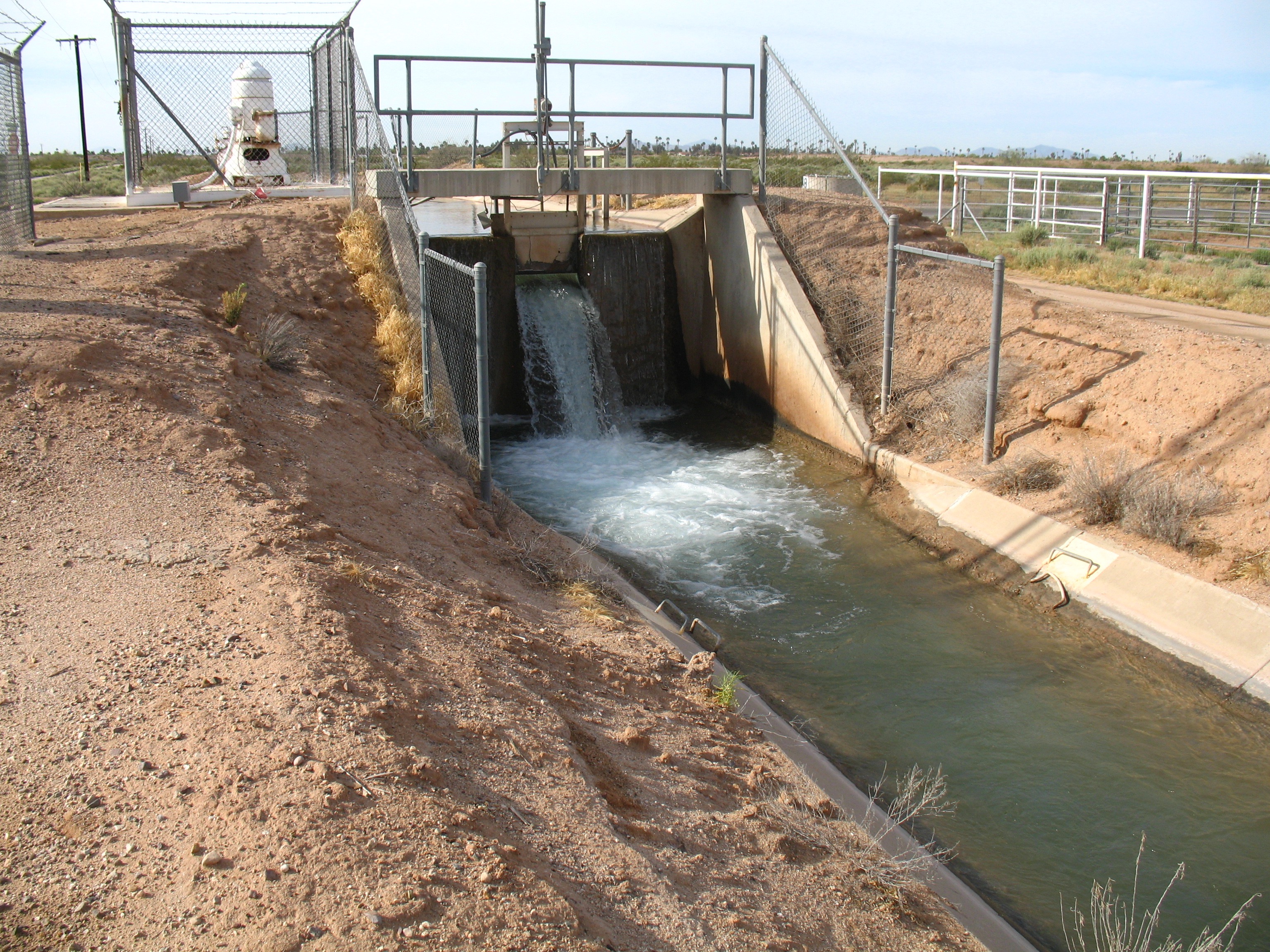
This particular field was vivid green, too, but with spring alfalfa, and the Colorado River was steadily and slowly pouring into it through a series of black plastic pipes, each about three inches wide, that curved into the field from a concrete irrigation ditch. For the first time, I’d pulled off the interstate to check out the fields; for the first time, I’d driven through downtown Casa Grande; for the first time, I was looking for this particular, unexpected end of the Colorado River.
For that’s what these black pipes were, the end of a vast distribution system that begins up north with the various dams—Flaming Gorge, Glen Canyon, Hoover, Parker—that block the flow of the Colorado and its tributaries and hold that water for later distribution. From there the water coursed hundreds of miles through the big canal of the Central Arizona Project, then branched off through an intricate system of arterial canals and laterals and ditches that could be controlled by a single man adjusting ditch valves and aligning the black plastic pipes so that the river, so willful and powerful in its native canyon habitat, could be harnessed for the singular task of quietly and dutifully watering a few rows of springtime alfalfa that would be fed to cattle somewhere nearby.
For someone who likes feeling the thrill of riding a powerful rapid, or simply standing high on Navajo Bridge and seeing the seemingly unstoppable and solid current pulsing far below, it seemed a comedown that a wild—or at least wildish—river could be harnessed into the quotidian task of watering some domesticated plants whose end product would be some quantity of milk or cheese or hamburgers. But this of course is true of almost all the ends of the Colorado, little to none of which ever finds the river’s original end down on the Gulf of California. The river, all of it, has been corralled for work. For productivity.
And now even that task is threatened. The flow of the Colorado is down around 20 percent in this century from its 20th-century average. Some of that decline is due to reduced precipitation in the high country, but some of it is due to higher temperatures, too. As temperatures continue to rise, it is reasonable to conclude that the overall decline in water supply is going to continue.
At least that is what farmers in Pinal County have to assume, for under the terms of a new statewide agreement they will first have to give up access to water delivered through the Central Arizona Project. If that happens, some may be able to switch to using groundwater instead—but that’s expensive. The upshot is that some of the fields that now show up as vivid green on Google Earth will become toast brown instead. As the river’s inflow diminishes, bit by bit, its outflow has to diminish, too, and fewer black plastic pipes flow onto the fields of Pinal County.
None of this is likely to make much of an impression on those drivers shooting by on I-10—a little more brown on the landscape, a little less green—except when the wind blows, for the bare fields of Pinal County are a major source for the dust-laden haboobs that blow into Maricopa County during summer storms. Think of it as a case study for how climate change ripples through the complex systems we have set up: higher temperatures translate into less water in Lake Mead, which translates into less water for the CAP, which translates into decisions by farmers to leave some of their land unplanted, which translate into dust storms that imperil highway traffic and leave people in Phoenix coughing and having to clean up the grit.
Where does a river end? The Hopi say it never really does, that it flows out to sea and that the sun then conveys it back up into the sky to fall again as rain or snow. It’s a nice visualization of how the water cycle works. But for the Colorado’s countless ends, the more important question might be: how many ends are we willing to experience before we’re willing to do what it takes to ensure the river’s long-term health?
